On your way to the Hampton Roads area for a visit? When traveling tothe Hampton Roads area, traffic congestion and the confusing array of bridges and tunnels can befrustrating! Read these tips for a smoother ride!
Bordered by that Atlantic, on the shores of the Chesapeake Bay and beribboned with rivers, visiting coastal Kiptopekefrom outside the Hampton Roads area one or more of the area's bridges and/or tunnels must be used.

Check tunnel and bridge height/weight restrictions and traffic conditions on your way to coastal Virginia state parks for a smoother ride!
To help keep traffic flowing, here for a detailed VDOT information page about height and weight restrictions and propane tank inspectionson the bridges and tunnels inthe Hampton Roads area.
The following list of abbreviations and location informationcan help you navigate the area and get to your state park destination on time and in a good mood! Sometimes,drivers areencouraged or required to take analternate routedue to accidents or congestion. Please print this blog post and put it with your reservation information!
CBBT = Chesapeake Bay Bridge-Tunnel is located on Highway 13 connecting Virginia Beach to the Eastern Shore Peninsula; going over and under the Chesapeake Bay) $12 one way toll; $17 round trip toll if completed in 24 hours. The Chesapeake Bay Bridge-Tunnel is a destination in and of itself with a gift shop, observation deck and fishing pier.
HRBT = Hampton Roads Bridge-Tunnel is located on I-64 between Norfolk and Hampton; going over and under the James River
MMBT = Monitor Merrimac Bridge-Tunnel is located on I-664 connection Hampton and Portsmouth; going over and under the James River
HRB = High Rise Bridge is located on I-64 at the southern end of Chesapeake; going over the Elizabeth River
JRB = James River Bridgeis located on Route 17 connecting Hampton and Suffolk; going over the James River
Berkley Bridge and Downtown Tunnelis located on I-464 in downtown Norfolk; going over and under the Elizabeth River
Gilmerton Bridge is located off I-464 and Military Highway; going over the Elizabeth River
Midtown Tunnel is located on I-264 connecting Norfolk and Portsmouth; going over and under the Elizabeth River
Coleman Bridge is located on Route 17 connecting Newport News to the Northern Neck; going over the York River' $2 toll going north; no charge going south

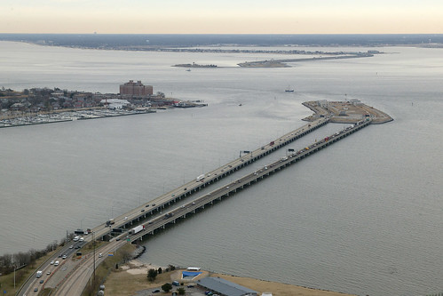
Aerial view of the Hampton Roads Bridge Tunnel (courtesy of VDOT Flickr page)
First Landing State Park is located in Virginia Beach. From I-64, take Northampton Blvd.-U.S. 13 North (Exit 282). Go through eight lights, then turn right at the Shore Drive/U.S. 60 exit (last exit before the Chesapeake Bay Bridge Tunnel). Take a right on Shore Drive and go four and a half miles to the park entrance. To reach the Chesapeake Bay Center, park office, camping or cabins, turn left off U.S. Rt. 60 at the stoplight and check in at the contact station. For the Trail Center, picnic area and trails, turn right instead.
Drive Time: Northern Virginia, three and a half hours; Richmond, two hours; Tidewater/Norfolk/Virginia Beach, 20-30 minutes (this facility is in the area); Roanoke, five and a half hours
